Planning a trip to Hawaii can feel exciting and overwhelming at the same time. The islands look close together on a map, yet each one offers a completely different travel experience. For tourists, a clear map of the Hawaiian Islands is more than a visual reference. It is a practical tool that helps shape routes, budgets, travel time, and expectations.
This complete guide explains the map of the Hawaiian Islands in a way that supports smart travel planning. It covers island locations, distances, airport access, travel routes, and how geography affects sightseeing. Whether you are visiting Hawaii for the first time or planning a return trip with a new focus, this guide will help you choose the right islands and move between them with confidence.
Rather than listing facts in isolation, this article connects the Hawaiian Islands map to real travel decisions. You will learn how each island fits into the chain, which islands work best together, and how to use the map to avoid common planning mistakes.
Why the Map of Hawaiian Islands Matters for Tourists?
Many travellers assume Hawaii functions like one large destination. In reality, the Hawaiian Islands are spread across the Pacific Ocean, with each island separated by open water and distinct landscapes. A map helps tourists see these separations clearly and plan travel days realistically.
The map also highlights why island hopping requires flights rather than ferries, why weather can differ between islands, and why some islands suit short stays while others need more time. Without a clear sense of location and distance, travellers often overbook activities or underestimate travel time.
For travel planning, the Hawaiian Islands map acts as a foundation. Once you know where each island sits and how it connects to the others, decisions about accommodation, transport, and itineraries become far easier.
Overview of the Hawaiian Islands Chain
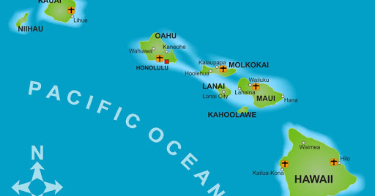
The Hawaiian Islands form a long chain stretching northwest to southeast across the Pacific. Only a portion of these islands are accessible to tourists. The main visitor islands are located toward the southeastern end of the chain.
The primary islands most tourists visit are:
- Oahu
- Maui
- Hawaii Island
- Kauai
- Molokai
- Lanai
On a map, these islands appear close together, but flight times between them range from 25 to 50 minutes. This spacing influences how many islands you can realistically visit in one trip.
Reading a Map of Hawaiian Islands for Travel Planning
A tourist-focused Hawaiian Islands map usually shows island names, major towns, airports, and sometimes key highways. Knowing how to read these elements helps with smarter planning.
Key features to look for on a map include:
- Location of international and inter-island airports
- Distance between islands
- Main population centres
- Coastal orientation and road layouts
- Mountain ranges and volcanoes
These details explain why some areas are easy to reach while others take longer, even on the same island.
Oahu on the Map
Oahu sits near the centre of the main Hawaiian island group and plays a key role in travel planning for most visitors. When looking at a map of the Hawaiian Islands, Oahu often stands out as the natural entry point due to its location, transport links, and range of services. For tourists, its position helps explain why so many trips begin or end here.
Why Oahu Is Central on the Map
Oahu is home to Honolulu and the largest international airport in Hawaii, making it the primary gateway to the islands. On the map, this central position allows Oahu to function as a travel hub. Inter-island flights operate frequently from here to Maui, the Big Island, Kauai, and smaller islands. This makes Oahu practical for arrivals, departures, and island hopping without complicated routing.
Key Areas Shown on the Map
Tourist maps of Oahu clearly mark Honolulu and Waikiki, where most hotels, shops, and beaches are located. Pearl Harbor appears nearby, highlighting how close major historic sites are to the city. The North Shore is shown along the island’s northern coast, known for surf beaches and smaller towns. Major highways circle the island, making it easy to see how beaches, urban areas, and mountain ranges connect within short driving distances.
Travel Planning Tip
Because Oahu is so well connected, it works well as either the first or last island in a multi-island trip. Starting here helps with flight availability and transport ease, while ending here simplifies international departures. Its compact layout also allows travellers to cover a wide range of experiences without long travel times, making it efficient for short stays or flexible itineraries.
Maui on the Map
Maui lies east of Oahu and appears slightly larger when viewed on a map of the Hawaiian Islands. Its position and shape play a major role in how travel unfolds on the island. For tourists, the map helps explain why Maui feels spacious and why planning accommodation location matters more here than on smaller islands.
Maui’s Geographic Layout
On the map, Maui looks like two main land masses connected by a narrow central valley. One side includes West Maui, while the other stretches toward South Maui and the eastern region leading to Hana. This layout explains why travelling between areas can take longer than expected, even though distances seem short. Winding roads and mountain terrain add to travel time.
Airports and Access
Kahului Airport is clearly marked on most tourist maps and serves as Maui’s main entry point for both mainland and inter-island flights. Smaller airports also appear on the map, mainly supporting short inter-island routes. Seeing airport locations helps travellers avoid booking accommodation far from arrival points.
Travel Planning Tip
The map makes it clear that staying in one main area reduces long daily drives. Maui rewards travellers who choose accommodation close to the activities they plan to focus on, rather than trying to cover the entire island from one base.
Hawaii Island on the Map
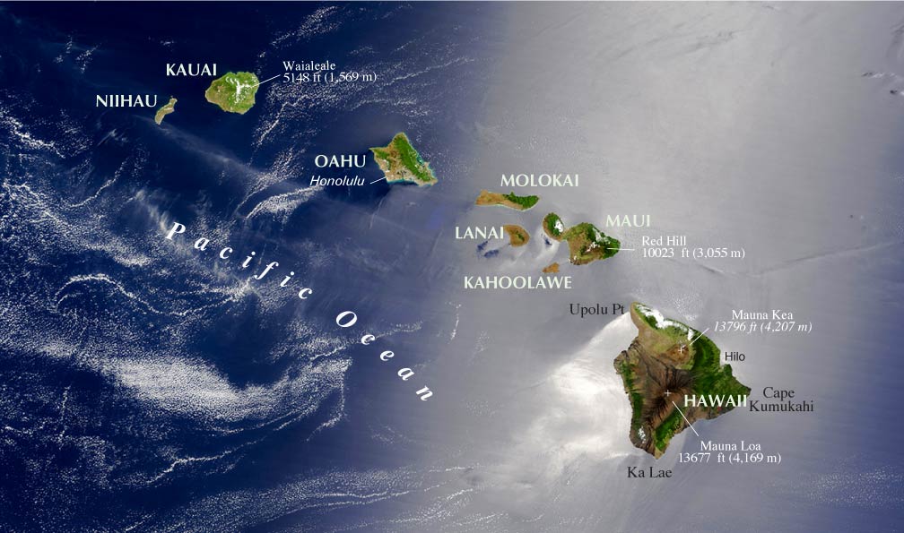
Often referred to as the Big Island, Hawaii Island dominates the map in both size and geographic variety. One look at the map explains why this island feels completely different from the others and why travel planning here requires more time and flexibility.
Scale and Distance
The map shows that Hawaii Island is larger than all the other main Hawaiian islands combined. This scale explains longer driving times and why day trips across the island are not always realistic. Distances between towns, beaches, and attractions can be significant, even when locations appear close on a map.
Key Geographic Features
Maps of Hawaii Island highlight active and dormant volcanoes, national parks, and sharply varied coastlines. Elevation changes are clearly visible and help explain why weather can differ greatly between regions on the same day. One side of the island may be dry and sunny, while another is cooler and wetter.
Travel Planning Tip
The map supports longer stays on the Big Island. Travellers who want beaches, volcanic landscapes, cultural sites, and changing climates benefit from staying several days in different areas, rather than trying to see everything through short drives or island hopping.
Kauai on the Map
Kauai sits northwest of Oahu and is widely recognised for its strong natural character. When viewed on a map of the Hawaiian Islands, its position immediately signals a quieter and more nature-focused travel experience. For tourists, this location helps explain why Kauai feels less busy and more relaxed than other islands.
Kauai’s Position
On the map, Kauai appears slightly separated from the central cluster of islands. This physical distance reflects its slower pace and lower visitor numbers. Fewer inter-island connections and a smaller population contribute to a calmer atmosphere, which appeals to travellers who value scenery and space over nightlife or shopping.
Key Areas
Maps of Kauai show limited road access along parts of the coastline, particularly along the rugged northern and western edges. This explains why certain areas can only be reached by boat, helicopter, or guided tours. The road network mainly follows the coast, reinforcing a slower style of travel.
Travel Planning Tip
Kauai suits travellers who prefer staying on one island and exploring at an unhurried pace. Its layout rewards longer stays and careful planning rather than fast-moving itineraries.
Molokai and Lanai on the Map
Molokai and Lanai appear between Oahu, Maui, and the Big Island on the Hawaiian Islands map. Their smaller size and limited infrastructure stand out when compared with the main tourist islands.
What the Map Reveals
The map shows that Molokai and Lanai have fewer roads, smaller towns, and limited airport access. This reflects their lower level of development and quieter way of life. Their placement between larger islands highlights how close they are geographically, yet how different the travel experience can feel once you arrive.
Travel Planning Tip
Molokai and Lanai work best as additions for experienced Hawaii travellers who already understand island travel logistics. They suit visitors seeking calm environments, minimal crowds, and a strong local focus rather than a wide range of tourist facilities.
Inter-Island Distances and Flights
The map of Hawaiian Islands shows relative distances, but flights are the main form of transport between islands.
Typical flight times include:
- Oahu to Maui: about 30 minutes
- Oahu to Big Island: about 45 minutes
- Maui to Kauai: about 50 minutes
Maps help travellers plan realistic connections and avoid stacking too many islands into short trips.
Using the Map to Choose the Right Islands
A Hawaiian Islands map helps travellers match geography with interests.
Examples include:
- City life and beaches close together: Oahu
- Scenic drives and resort areas: Maui
- Volcanoes and diverse climates: Big Island
- Lush landscapes and quiet beaches: Kauai
Seeing these islands in relation to each other helps avoid mismatched itineraries.
Island Hopping Based on Map Proximity
The map suggests logical island combinations.
Good combinations include:
- Oahu and Maui
- Maui and Big Island
- Oahu and Kauai
Less practical combinations involve multiple long flights or backtracking.
Climate Zones Shown on the Map
Climate in Hawaii changes noticeably from one area to another, even on the same island. A map that shows elevation, wind direction, and coastlines helps travellers see why weather can vary so much within short distances. This is an important factor for planning accommodation, activities, and daily travel.
Windward and Leeward Sides
Maps often show mountain ranges running through the islands, which explains the difference between windward and leeward sides. Windward areas face incoming trade winds and receive more rainfall, resulting in greener landscapes. Leeward sides sit in the rain shadow, making them drier and sunnier. This contrast is especially clear on islands like Maui and Oahu.
Elevation and Temperature Changes
Elevation markings on maps help explain temperature differences. Higher areas are cooler and may experience cloud cover, while coastal regions stay warmer. On Hawaii, this means a short drive uphill can feel like a different climate altogether. Travellers planning hikes or scenic drives benefit from checking elevation before heading out.
Microclimates Within One Island
Maps reveal why islands such as the Big Island contain multiple climate zones. Volcanoes, valleys, and coastlines create pockets of dry heat, rainforest conditions, and cooler uplands. Seeing these zones on a map helps travellers pack appropriately and choose activities that match daily weather conditions.
Travel Planning Tip
Using a climate-aware map helps with smarter accommodation choices. Staying on a drier coast may suit beach-focused trips, while greener regions appeal to travellers interested in scenery and waterfalls. Checking climate zones in advance reduces weather surprises and improves overall trip comfort.
Airports and Entry Points on the Map
Major airports marked on tourist maps include:
- Honolulu International Airport on Oahu
- Kahului Airport on Maui
- Kona and Hilo airports on the Big Island
- Lihue Airport on Kauai
Knowing airport locations prevents booking accommodation far from arrival points.
Road Layouts and Travel Time
Road layouts in Hawaii play a major role in how long it takes to move around each island. Distances may look short on a map, but geography, road design, and traffic patterns often extend travel time. Knowing how roads are structured helps travellers plan realistic daily schedules and avoid unnecessary rushing.
Why Hawaiian Roads Take Longer Than Expected
Most roads in Hawaii follow the coastline rather than cutting straight across islands. Mountains, valleys, and protected land limit direct routes, which means travellers often drive around natural features instead of through them. As a result, even short distances can take much longer than expected, especially on larger islands.
Circular Road Systems on the Islands
Many Hawaiian islands rely on circular or semi-circular road systems. These roads loop around the coast and connect towns, beaches, and resorts. While this layout provides scenic drives, it also means there are few shortcuts. Missing a turn can add significant time, as turning back may require long detours rather than quick corrections.
Impact of Mountains and Terrain
Mountain ranges and volcanic landscapes strongly influence travel time. Steep slopes, winding roads, and narrow passes slow traffic, particularly on islands like Maui, Kauai, and the Big Island. Some areas have single-lane bridges or sharp curves, which further reduce driving speed and increase travel time compared to mainland roads.
Traffic and Peak Travel Hours
Traffic congestion is common near major towns, airports, and popular beaches, especially during morning and late afternoon hours. On Oahu, traffic around Honolulu can significantly extend short drives. Planning travel outside peak hours helps reduce delays and keeps daily plans more flexible.
Travel Planning Tip
Maps help travellers see road patterns clearly before arrival. Choosing accommodation close to key activities reduces daily driving and makes trips more relaxed. Instead of covering the entire island each day, focusing on one region at a time leads to smoother travel and better use of time.
How Many Islands Should Tourists Visit?

The map supports realistic pacing.
- 1 island for trips under 7 days
- 2 islands for trips of 10 to 14 days
- 3 islands only for longer stays
Trying to cover too much leads to rushed travel.
Common Map-Related Mistakes Tourists Make
- Assuming islands are connected by ferries
- Underestimating driving times
- Booking accommodation without checking location
- Planning day trips that are not realistic
A careful look at the map prevents these issues.
Best Map Types for Hawaii Travel Planning
Tourists benefit from:
- Political maps with island names
- Transport maps with airports
- Road maps for each island
- Physical maps showing mountains
Using more than one map type improves planning accuracy.
Digital vs Printed Maps
Choosing between digital and printed maps plays a role in how smoothly travel plans unfold across Hawaii. Each format serves a different purpose, and many travellers find value in using both together rather than relying on only one option.
Digital maps are useful for live navigation, real-time traffic updates, and route adjustments while driving or walking. They help with turn-by-turn directions, nearby services, and travel time estimates. Printed maps, on the other hand, provide a clear big-picture view of each island. They make it easier to visualise distances, coastlines, and regional layouts without constant screen use. Using both allows travellers to plan routes in advance and navigate confidently on the ground.
Sample Island Routes Using the Map
A map of the Hawaiian Islands helps tourists see which island combinations make sense for different travel styles. For first-time visitors, pairing Oahu with Maui works well. Oahu provides urban life, beaches, and history, while Maui adds scenic drives and resort areas, all within short flight connections.
For nature-focused travel, combining Kauai with Hawaii Island offers variety in landscapes and outdoor experiences. The map makes these route choices clear by showing proximity, flight times, and logical travel flow, helping travellers avoid unnecessary backtracking or rushed schedules.
Must Read:
- Best Greek Islands to Visit: A Complete Travel Guide
- Best Time to Go to Oregon for Budget Travellers
- Best Time to Visit Bermuda for First-Time Travellers
Final Thoughts:
A clear map of the Hawaiian Islands is one of the most valuable tools for tourists. It shows more than names and shapes. It explains distance, access, climate, and travel logic in a way no checklist can.
By using the map early in the planning process, travellers avoid rushed schedules, reduce stress, and make better choices about where to go and how long to stay. Hawaii rewards thoughtful planning, and the map is where that planning should begin.